
Hello, dear reader! You may know Peru because of Machu Picchu, the Andes, or its famous cuisine, but before planning a trip, it helps to know exactly where this fascinating country is on the map.
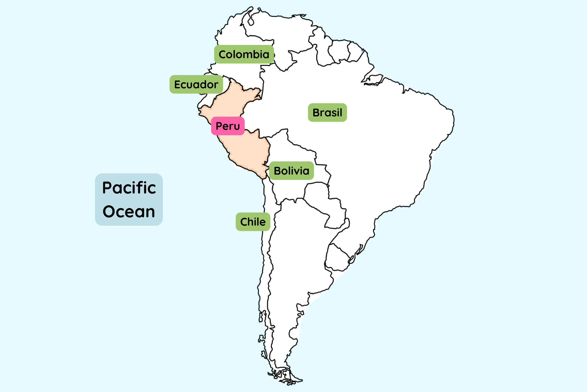
Peru is located on the western side of South America, along the Pacific Ocean. It shares borders with five countries: Ecuador and Colombia to the north, Brazil to the east, Bolivia to the southeast, and Chile to the south. Its location is one of the reasons Peru is such a geographically diverse destination, bringing together Pacific coastlines, the Andes Mountains, and the Amazon rainforest in one country.
And here is the exciting part for travelers: these are not just different places on a map. They are completely different travel experiences.
Where Is Peru on the Map?
If you look at a map of South America, Peru is on the continent's western coast, facing the Pacific Ocean.
Peru is entirely in the Southern Hemisphere and the Western Hemisphere.
Its position may look relatively close to the Equator on a world map, but the Andes Mountains and the Pacific Ocean strongly influence its landscapes and climate.
Peru is also one of the largest countries in South America, covering about 1.29 million square kilometers. From west to east, its geography changes dramatically: you can go from a dry Pacific desert to high Andean mountains and then descend towards the Amazon Basin.
That is why a trip to Peru can feel like visiting several different worlds in one vacation.
Do you dream with visiting Peru? Don't hesitate to contact us!
Which Countries Border Peru?
Peru shares land borders with five South American countries:
- Ecuador to the north and northwest
- Brazil to the east
- Bolivia to the southeast
- Chile to the south
To the west, Peru has the Pacific Ocean rather than a land border.
This location also makes Peru an interesting starting point for a larger South American trip. It is geographically connected to countries such as Bolivia, Chile, Ecuador, Colombia, and Brazil, although most travelers visiting Peru for the first time focus on exploring the country itself.
Where is Peru located?
Why Does Peru Have So Many Different Landscapes?
One of the easiest ways to understand Peru is to look at its three major natural regions: the Coast, the Andes, and the Amazon. Peru Travel describes these three areas as distinct geographic environments, and their differences are especially important when planning a trip.
The Coast: Deserts, Beaches and Lima the Capital of Peru
Along the Pacific coast, Peru combines desert landscapes, beaches, fertile river valleys, and major cities.
This is where you will find Lima, Peru's capital and the country's main international gateway. Further south, places such as Paracas, Ica, Huacachina, and Nazca show just how unusual the Peruvian coast can be: desert dunes, wildlife-rich waters, archaeological sites, and fascinating geoglyphs all exist within the same region.
Further north, cities such as Trujillo and Chiclayo open the door to another side of Peru, with colonial heritage and important pre-Inca archaeological sites.
The Peruvian coast covers only around 11% of the country's territory, but it is home to more than half of its population.
The Andes: Cusco, Machu Picchu and the Mountains
Moving inland, the landscape rises sharply into the Andes Mountains. This is where you will find some of Peru's most famous destinations, including Cusco, the Sacred Valley, Machu Picchu, Huaraz, Arequipa, and Puno.
Cusco is an especially important point on the travel map because it is the main gateway to Machu Picchu and one of the most important cities for exploring the surrounding Andes.
And although people often associate Machu Picchu simply with “Cusco”, there is an important geographic detail: Machu Picchu is located in the Cusco Region, in a lush mountain environment where the high Andes begin to transition into cloud forest.
This explains why a journey from Cusco to Machu Picchu can feel so different from what you might expect from a mountain destination.
The Amazon:
To the east of the Andes lies the Peruvian Amazon. The Amazon region covers roughly 59% of Peru's territory, making it much larger geographically than many first-time visitors realize. It includes immense areas of rainforest, rivers, wetlands, and tropical ecosystems.
Two important gateways for travelers are Iquitos in northern Peru and Puerto Maldonado in the south.
Iquitos is especially unique because it has no road connection to Peru's main national highway network and is generally reached by air or river. Puerto Maldonado, meanwhile, is a popular starting point for exploring the biodiversity of the southern Amazon, including the Tambopata area.
So when you ask “Where is Peru?”, the answer is not simply one point on a map. It is a country that stretches from the Pacific coast, across the Andes, and deep into the Amazon Basin.
Where Are the Most Popular Places to Visit in Peru?
A map becomes much more useful when you can actually picture where the places you hear about are located.
Here is a simple geographic guide to some of Peru's best-known travel destinations:
Peru Map: Where Are the Cities and Places You'll Visit?
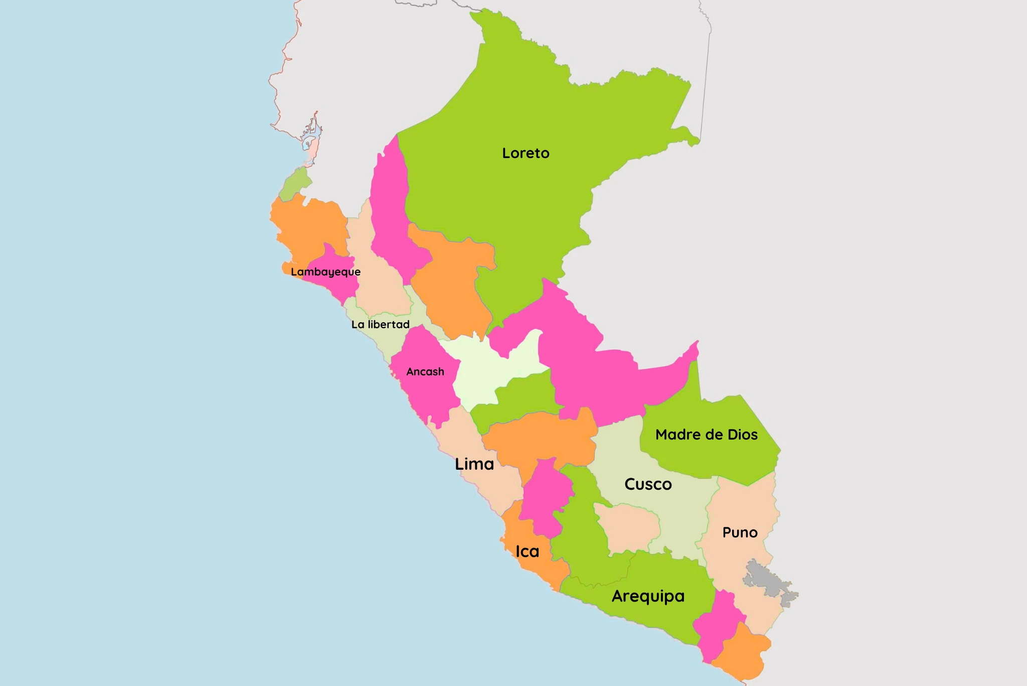
A travel-focused map showing Lima, Ica (Paracas, Huacachina, Nazca), Arequipa (Colca Canyon), Puno (Titicaca Lake), Cusco (Sacred Valley, Machu Picchu), Ancash (Huaraz), La Libertad (Trujillo), Lambayeque (Chiclayo), Madre de Dios (Puerto Maldonado), and Loreto (Iquitos).
A map like this can make planning your Peru vacation much easier. Instead of seeing a list of famous names and assuming they are all close together, you can understand how far apart they actually are and why most Peru itineraries combine flights, trains, private transportation, and road journeys.
For example, a classic Peru itinerary might begin in Lima, continue to Cusco and the Sacred Valley, and then reach Machu Picchu. A longer trip can add southern destinations such as Arequipa and Puno, or continue into the Amazon.
Peru's geography is a big part of the adventure.
Is Lima Close to Machu Picchu?
One of the most common questions from first-time travelers is where Machu Picchu actually fits into the map.
Machu Picchu is not in Lima, and it is not in the middle of the Amazon. It is located in the Cusco Region, northwest of the city of Cusco, in a mountainous area covered by cloud forest.
Most visitors first travel to Cusco, then continue toward the Sacred Valley and Machu Picchu by train or trekking route. Depending on the itinerary, travelers may stay in Aguas Calientes (Machu Picchu Pueblo) before visiting the archaeological site.
Understanding this geography makes the trip much easier to visualize before you arrive.
How Do You Get Around Peru?
Because Peru is a large country with very different geographical regions, traveling between destinations is not always as simple as looking at two cities on a map.
For international visitors, Lima is usually the main arrival point and also an important hub for domestic travel. From Lima, travelers can connect by air to destinations such as Cusco, Arequipa, Iquitos, and other major cities.
Within the country, the best transportation depends on the route. Flights are useful for covering long distances, while trains are an important part of many Machu Picchu journeys. Road travel is particularly useful for exploring destinations where the journey itself is part of the experience.
This is one reason having a well-planned itinerary can make such a difference when traveling in Peru.
Learn more about Airports in Peru
What Does Peru's Location Mean for Travelers?
Peru's geography is more than an interesting fact. It directly affects your trip.
You can enjoy the Pacific coast in Lima, walk through ancient Inca sites in the Andes, and then explore tropical rainforest ecosystems in the Amazon...sometimes during the same vacation.
It also means that weather, altitude, and landscapes can change significantly from one destination to another. A sunny day on the coast does not necessarily mean the same conditions in Cusco, and the rainforest is a completely different environment again.
Knowing where each destination sits on the map helps you understand why Peru offers such a wide range of experiences … and why packing, transportation, and itinerary planning matter.
Ready to See Where Peru Takes You?
Now that you know where Peru is on the map, the next question is probably the more exciting one: Where should I go first?
At Peruvian Sunrise, we help travelers discover Peru through carefully planned private journeys, from classic Machu Picchu vacations to longer itineraries combining the Andes, the coast, and the Amazon.
Our Machu Picchu Sunrise itinerary combines Lima, Cusco, the Sacred Valley, and Machu Picchu in 7 days, while longer journeys such as The Best of Peru add destinations including Puno and Puerto Maldonado. For travelers with more time, our Peru a la Carte itinerary brings together the coast, Andes, and Amazon in one trip.
Because once you know where Peru is, the real adventure begins with deciding where in Peru you want to go.
Explore our Peru tours and start planning your journey with Peruvian Sunrise!
FAQs
What continent is Peru in?
Peru is located in South America.
What countries border Peru?
Peru shares borders with Ecuador, Colombia, Brazil, Bolivia, and Chile. The Pacific Ocean forms its western boundary.
Where is Machu Picchu located?
Machu Picchu is located in the Cusco Region of Peru, in the Andes, within a mountainous cloud-forest environment.
Where is Cusco in Peru?
Cusco is located in southern Peru, in the Andes Mountains. It is one of the country's most important tourism hubs and the main starting point for many Machu Picchu journeys.
Is Peru in Central America?
No. Peru is in South America, not Central America.